
Alaska is the largest state in the United States by area, spanning 586,412 square miles. To put it into perspective, Alaska is about twice as large as Texas and three times the size of California!
Alaska is larger than most countries in the world — if it were a country, it’d be the 33rd largest.
If you’re genuinely curious about the size of Alaska, this article will give you the visual perspective you’re likely missing.
18 Curious Facts About Alaska
The name Alaska comes from the Aleut word “alaxsxaq” which means “the mainland” or literally, “that which the sea breaks against.”
Alaska geographically stands alone, completely apart from the continental United States. Its only border is Canada and the coastline.
Roughly 60% of Alaska is owned by the federal government, which leaves the remainder for private use. It has over 3,000 miles of coastline – more than all but four countries in the world!
Alaska was purchased from Russia by the United States in 1867 for $7.2 million ($123 million in today’s [2022] dollars) at about two cents per acre ($4.74/km²), payable in gold. It was admitted as the 49th state of the U.S. on January 3, 1959.
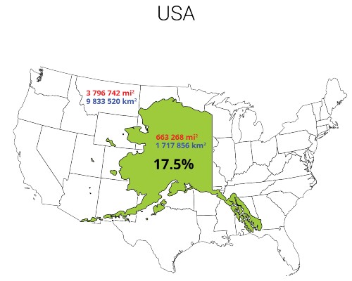
Alaska is the largest U.S. state, occupying 663,300 square miles, making it more than twice as large as Texas, the second-largest state.
Alaska contains over half of the world’s glaciers, more than 100,000, covering around 5% of the state.
Alaska has a longer coastline than all the other U.S. states combined at approximately 34,000 miles.
The state’s population is around 724,357 as of 2022, making it one of the least densely populated states in the U.S.
The city of Juneau is the only U.S. state capital without road access to the rest of the state.
Alaska is home to North America’s highest peak, Denali, standing at 20,310 feet.
The state is known for its diverse wildlife, including grizzly bears, moose, caribou, wolves, and various species of salmon.
About 17 of the 20 highest peaks in the U.S. are located in Alaska.
More than half of the land in Alaska is owned by the U.S. federal government, it includes national forests, national parks, and wildlife refuges.
Alaska has an estimated 100,000 black bears and 30,000 brown bears, the largest population in the U.S.
It has over 3,000 rivers and 3 million lakes, making it a popular destination for fishing.
The Northern Lights, or Aurora Borealis, can often be seen in the Alaskan night sky.
Alaska is known for its major industries: oil, gas, fishing, and tourism. Oil production, in particular, has been a significant part of the Alaskan economy.
The Alaska Highway, completed in 1942, connects the contiguous U.S. to Alaska through Canada.
The indigenous peoples of Alaska, known as Alaska Natives, make up over 15% of the state’s total population, and their culture greatly influences the state’s identity.
The Population of Alaska
Approximately 724,000 people live in Alaska, making it the 4th smallest state by population.
- Wyoming (Population: 581,075)
- Vermont (Population: 623,251)
- District of Columbia (Population: 714,153)
- Alaska (Population: 724,357)
The capital city is Juneau, which has a population of approximately 32,000 people. By comparison (cities randomly selected), New York City has a population of 8.4 million, and New Orleans has a population of 390,000.
Want to Connect With a Community of Over 1,078 RV Enthusiasts?
More than 20 distinct languages are spoken in Alaska, making communication interesting in remote areas of the state.
Over 25% of the population live in Anchorage (293,000), which is Alaska’s major social hub.
6 Images That Provide Perspective on the Size of Alaska
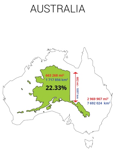
#1 of 6: Visualize Alaska within Australia
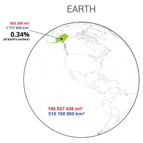
#2 of 6: Visualize Alaska and Earth
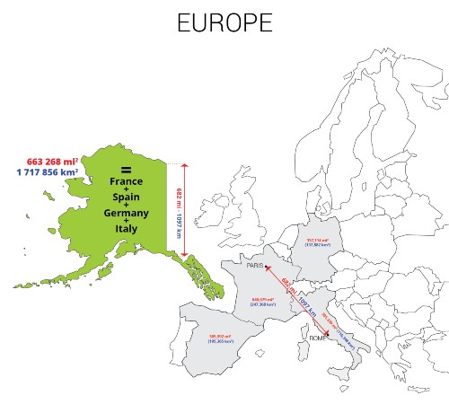
#3 of 6: Visualize Alaska and Europe
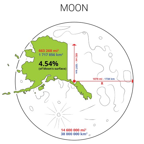
#4 of 6: Visualize Alaska on the Moon
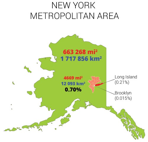
#5 of 6: Visualize Alaska and the New York Metropolitan Area
#6 of 6: Visualize Alaska and the Continental United States
How Big Is Alaska Actually? (Video)
Related Questions
1. How does the size of Alaska compare to the entire United States?
Alaska is so large that it makes up about 17% of the total land area of the United States.
2. What proportion of Alaska is covered by forests?
Approximately 129 million acres, or about 30% of Alaska’s land area, is covered by forests.
3. How many national parks are there in Alaska, and what proportion of the state’s area do they cover?
There are 23 national parks in Alaska, covering about 54 million acres, which is approximately 13% of the state’s total area.
4. How does the size of Alaska’s largest city, Anchorage, compare to the size of the entire state?
Anchorage covers about 1,961 square miles, which is only about 0.3% of the total area of Alaska.
5. How large is the area of Alaska that lies within the Arctic Circle?
About 80,000 square miles, or roughly 13% of Alaska’s total area, lie within the Arctic Circle.
")

")

"Man cannot discover new oceans unless he has the courage to lose sight of the shore."
-- Andre Gide


